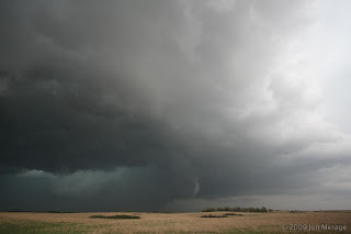
Storm Chasers Discovery Channel ’09!

Posted on: September 3rd, 2009 by Jonathan Merage 1 Comment

Going into its 3rd season, the Storm Chasers Series on the Discovery Channel premieres Oct. 18 at 8/10pm MT/ET…

The chasers & their intrepid crews work to get INSIDE several twisters, with a few successful intercepts- including one noted tornado which our team was VERY near- LaGrange, Wyoming!!
From what I’ve heard, they might even have the elusive & dangerous “straight-up view” into a tornado! We know they made a DIRECT intercept with the June 5th Wyoming tornado, with the hefty TIV crossing into the debris field during the tornado’s stronger stage and Reed Timmer’s Dominator getting passed directly OVER by the twister at a different point. Either way, the super-successful teamwork of VORTEX2 during the June 5th Wyoming intercept & study should make this a very interesting series.

Here’s a fun clip from the Season 2 finale:

Lightning Storms on Aug. 17

Posted on: August 24th, 2009 by Jonathan Merage No Comments

This afternoon a flurry of slow-moving storms went up between 4-5 pm. I managed to capture a few of the closer strikes on video. Average distances were no more than two miles away!

First “strike” was very impressive. Actually consisted of four separate bolts hitting in rapid sequence, with the last bolt generating about 4 flashes before discharging (furthest left in the center picture). Of course, that all happened in 1.1 seconds (:-)
Later that night, areas from Denver south got hit with hail & more lightning. The foothills & adjacent mountains were also pummeled by an elongated thunderstorm that generated prolific lightning up until late night. I was unfortunately stuck in a meeting at that time.


*UPDATE*
Just for kicks, here’s the video clip of that powerful strike:

Posted on: August 13th, 2009 by Jonathan Merage No Comments

Just got back from a nice trip to Southern Cali for a visit with family & friends. We basically split our time between Newport Beach & LA. Been a while, but I did manage to snap a few sweet cloudscapes from the air. Gotta make the most of every moment…. (;-)

Just below cruising altitude on the way there

Here’s a low-res shot of the Grand Canyon from 30,000 ft.

Posted on: July 13th, 2009 by Jonathan Merage No Comments

Caught the tornado in extreme northeast Wyoming today, albeit from a distance!! Touched down at 6:35pm MDT in Crook County near I-90 just west of the South Dakota border. We observed the tornado during the latter half of its life cycle for several minutes prior to rope-out from the town of Belle Fourche (French for “beautiful fork”).

Unfortunately, large hills & road construction prevented us fom getting a clear visual of the reported “large tornado”, but nevertheless the fact that our target area verified (along with SPC’s very accurate 10% tornado risk!) as having produced the ONLY large tornado of the day was great! My only great regret is not having my camera & zoom lens on hand to capture it. Did get nice video of the VERY structuresque supercell though!

More details soon…

Posted on: July 10th, 2009 by Jonathan Merage No Comments

Been a while since I updated the blog, so here’s a few favorite pics:

La Grange, Wyoming tornado during its mature stage

Less than a mile away!

Close-in shot of the symmetrical vortex wrapping itself in rain & hail

Posted on: May 18th, 2009 by Jonathan Merage No Comments

Finally got a chance to get the mesonet rack mounted! After considerable difficulty in finding the Yakima rail clamps & getting everyone on the same schedule (mounting this thing alone would’ve been impossible), we got her done!

We already drove through a tremendous rain & wind storm that barreled through OKC the next day and the system held up perfectly. Initially, I was concerned that any rain or moisture might leak between the clamps’ rubber grip & roof rail causing the whole thing to slip, but that wasn’t the case at all. Next step: get all wires connected & a gel-based car battery to power the rig (or power it thru the car’s battery), then get the software installed that will analye the raw data and display it in real-time on my laptop screen.

The system was designed to instantly measure & display local atmospheric variables such as temperature, moisture & humidity, air pressure, and precise wind speed & direction. All readings are updated continuously on a computer screen.

Setting up the mesonet bracket

Duct taping some sharp corners

Yeahh!! All mounted up (:-D)

Almost Ready to go!!

Posted on: May 15th, 2009 by Jonathan Merage No Comments

Went on an incredible storm chase in north-central Oklahoma, starting the day in Enid with low tornado potential overall. Tracked a couple storms that erupted over west-central part of the state & quickly became awesome lightning producers but very high-based with almost nil tornado potential. After enjoying those, we headed north/east to Enid then to I-35 hoping to intercept a couple of tornado warned supercells, only one actually produced before we caught up to it, so we shot south on I-35 to Guthrie (just north of OKC) & intercepted an INCREDIBLE massive lightning storm with some rotation but mostly powerful positive CG lightning with cannon-fire thunder!
The lightning gradually became constant around/after sunset & we were treated to one of the most powerful and highly visible lightning super-storms we had witnessed in a long time.
Photos are minimally post-processed to enhance visibility & contrast. ENJOY!

Positive CG strike beneath rotating storm at Guthrie, OK

Gorgeous Curling Lightning

Just east of Edmond, OK

Powerful double strike not far away

TRIPLE Cloud-Ground Strikes!!!

Posted on: May 11th, 2009 by Jonathan Merage No Comments

Notwithstanding a highly conditional chase day tomorrow (parameters look fantastic, but a strong CAP might prevent anything from happening), Wednesday starting to look interesting.
As of this point, I won’t be posting any details on locations or target areas until up to several days after the fact, but will continue to post pictures and even short video clips from any successful chases, time permitting of course.

Today is a down day (i.e. no storm chasing). The crews are working on installing specialized software that will collect all data from each of the mesonet vehicles & display it in real time on the FC’s (Field Coordinator’s) computer screen. The name of the game for this project is keeping as many facets of the operation (especially redundant tasks) running as smoothly & automated as possible. The technology behind this is really amazing! Anyway, here’s another cool tornado picture from my collection (click for larger image)…

More info soon…

VORTEX2 Media Day, TX/OK Red River Gentleman’s Chase

Posted on: May 9th, 2009 by Jonathan Merage No Comments

The Naval Post-Graduate School’s CIRPAS Radar
(NASA funded, used to coordinate Unmanned Autonomous Systems
i.e. self-guided aerial vehicles, in adverse weather)

Yesterday presented us with an awesome local chase after the fun & informative media day at the National Weather Center, with storms forecast to go up within the extreme instability/moisture axis across south-central OK by mid-late afternoon. For once, the forecast models verified with HUGE supercells forming shortly BEFORE sunset with tops shooting up to 70,000 feet within an environment characterized by 5,500 CAPE!! Many pictures to sort thru, so here’s a few of the best:

Howie Bluestein’s UMASS Close-Range Tornado Radar

CSWR (Center for Severe Weather Research) Support Vehicles

NSSL mesonet minivans fully equipped & ready to go

Cloud-ground lightning just north of Thakerville, OK (far south-central OK).
It was around 11:15pm & the lightning became constant, with flashes to our north & east.


Norman Trip

Posted on: May 7th, 2009 by Jonathan Merage No Comments

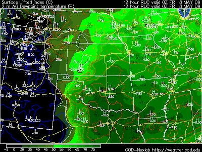
Staying in Norman, OK over the past week into this weekend. Gearing up for VORTEX2 & a potent local storm chase tomorrow. Oklahoma City NWS mentioning giant hail & tornadoes–not at all surprising considering the progged 7500 SBCAPE into tomorrow afternoon/evening with SBCIN almost completely eroded. Dewpoints pooling to upper-70s over a wide swath from DFW-Wichita Falls-southern OK.


Only concern is the almost total lack of helicity & rapid movement of the cold front (outflow dominant storms?). Mesoscale (storm-scale) interactions in such a strongly mixed atmosphere might be the only real hope for severe wx.